For further information, what it's all about, minimal explanations, more walks, etc., go to the main Walks page.
| Auckland
| North Shore
| Kauri Park
| Paths
| 2008
| January
| 1
| Northcote and Birkenhead harbourside booklet, Kauri Park leaflet
| N42:225638??
|
|
| We wanted to start from Balmain Road, as documented in the N&BHB ( curiously, on page 15 ), but the path isn't there. It looks as though a house has been built over it; we have certainly been that way at least once, but apparently no more. ( Perhaps this accounts for our difficulties last time ? ( 2007 February 6 ) )
Therefore, we went to the Hebe Place entrance. ( NOTE : The entrance is right at the bottom of the hill. If you park in the tempting car park part way down you have an interesting climb to get back. ) We went round the outside cycle, clockwise ( from above ). It's still an enjoyable walk, and there's a bridge near a pretty waterfall between Hebe Place and the main track.
We did follow a track to the left shortly after joining the main track. It became clear that it was not a maintained track ( though clearly well used ); it then became clear that it was the same track as that we explored last February. In view of our discovery that the Balmain Road entrance has vanished, it seems quite likely that we were on the Balmain Road track, now leading nowhere.
|
| Auckland
| North Shore
| Shepherd's Park
| Cresta Avenue car park to eastern corner
| 2008
| January
| 26
| Northcote and Birkenhead harbourside booklet; Newer information ( with map );
There's a sort of map at the car park.
| N42:205679
|
|
| Follow footpath through bush, keeping left where sensible. Down to sea, up to headland, round into inlet. Easy; well kept paths.
|
|
|
| Coast walk
| Shepherd's park to Kaipakiti creek, somewhere around the end of Packham Place ( - and back )
|
|
|
| The map shows a little bit of the path, but not nearly all of it; it continues round the coast to Beachhaven Road.
|
|
|
| Turn left down into inlet and across bridge; follow the path. ( Now well-defined and apparently maintained. )
|
|
|
|
| Eastern corner to Cresta Avenue car park.
|
|
|
| Northcote and Birkenhead harbourside booklet; Newer information ( with map ).
|
|
|
| More inland, via the "pavilion". Some information there.
|
| Auckland
| North Shore
| Tuff Crater
| Heath Reserve ( Exmouth Road ) to motorway via south bank, and back.
| 2008
| January
| 27
| Northcote and Birkenhead harbourside booklet.
| N42:270659
|
|
| No noticeable change. Pleasant, except for the motorway.
|
|
|
|
| Heath Reserve ( Exmouth Road ) to motorway via north bank.
|
|
|
| Northcote and Birkenhead harbourside booklet.
|
|
|
| No startling change; the paths are better than I remembered, and the bush has grown a bit more, which is nice.
Since last year, they've messed up the motorway a lot. Now it appears that you can't get across the bridge to walk right round.
We spent a little time looking for an effective way in at this corner. There's a path from "Warehouse Way", between The Warehouse and Canon, but there is no visible place for human beings to park. Typically stupid.
|
|
|
|
| Motorway to Arahia Street.
|
|
|
| Northcote and Birkenhead harbourside booklet.
|
|
|
| Jean thought she'd like to see where it went.
|
|
|
|
| Arahia Street to car.
|
|
|
| Exploration.
|
|
|
| Road. The other way is better.
|
| Auckland
| North Shore
| Eskdale Reserve
| Lauderdale Road to Kaipatiki Creek, and back
| 2008
| January
| 7
| Eskdale Park leaflet; Northcote and Birkenhead harbourside booklet; Exploration.
| N42:225676??
|
|
| Into Lauderdale reserve. We stopped at the first park notice we found in Lauderdale Road. It was a sort of plant shop; no one was there. We found a way through the back fence, but it wasn't any of the entrances marked on either map. Not recommended.
We found a bridge, crossed it, turned left, and continued along the east side of the water. The path apparently continues to Kaipatiki Road; we didn't go that far.
On the way back, we crossed the stepping stones into the reserve, and recognised that as the place we'd started from last time; then we went back to the path.
|
|
|
|
| Lauderdale Road towards Glenfield Road, and back.
|
|
|
| Eskdale Park leaflet; Northcote and Birkenhead harbourside booklet; Exploration.
|
|
|
| Our intention was to follow the path towards the west end of the reserve, following the loop near Domain Road round the head of the stream and returning by the shortest way back.
It is clear that both our maps are grossly out of date. The path is now wholly along the north side of the stream in the western part of the reserve, but it's clear enough. ( There are also several side tracks, some apparently well used; we explored one, to the north, until it ended at a notice saying "Dead end". )
The track towards Domain Road is there, but doesn't turn round at the top. Instead, it leads out to a grassy bit between the bush and Domain Road; we followed the edge of the the bush round quite a lot of Domin Road then Glenfield Road, and finally found a way back in which might have been the short stub track marked on both maps. We took the firt left turn, but then found that both the maps are effectively useless - there are far too many tracks on the ground. By selecting paths which led down or westish, we did eventually find ourselves back more or less where we had intended. ( We found a way out which wasn't the plant shop. )
It was an enjoyable walk, but rather spoilt by the silly maps.
|
| Auckland
| North Shore
| Kauri Point Domain
| Road to beach, and back
| 2008
| February
| 2
| Northcote and Birkenhead harbourside booklet; N&B web site
| N42:220649
|
|
| As before, more or less. Still very pleasant. We wandered off to the right of the track ( north ) just before the descent to the beach, and found a pretty view. Then we wandered off from the beach reserve into the bush and found nothing very exciting, though we did get back to the road.
On the way back, just before the gate, we noticed what looked a bit like a path going off to the right ( south ). Thereafter :
|
|
|
| Kauri Point Domain
| ANOTHER PATH, and back.
|
|
|
| Exploration.
|
|
|
| It's a well-trodden path, identified by occasional blue markers. There seem to be one or two side tracks, but we didn't try them. ( Later. )
It goes by a fairly roundabout route to a viewpoint above the south end of the beach. There's a very steep crumbly clay "path" down, which we didn't try.
It's much more fun than the road.
BUT THERE'S MORE .....
| 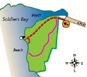
( The map is from the N&B web site; I added the purple line as a ROUGH representation of this path. )
|
| Auckland
| North Shore
| Kauri Glen
| various
| 2008
| February
| 3
| Harbourside Bush Walk Trail; Kauri Glen and Cecil Eady Bush leaflet; "Kauri Glen and Cecil Eady Bush"
| N42:250659
|
|
| In from Tui Glen Road.
Our intention was to follow the path through from Tui Glen Road to Lake Road by the shortest route, then to return by the more southerly route up to Kauri Glen Road, thence back to Tui Glen Road.
We first bent the forward part of the plan in following what seemed to be an informal track which cut out a loop and the first two bridges. As on our previous visit, the second and third of the two bridges on the official route were, respectively, blocked and absent.
Apart from that, we completed our planned walk, more or less, but had some difficulty in fitting the paths we found to the map. Later reference to the "Kauri Glen and Cecil Eady Bush" website returned a map showing a set of paths rather different from those marked on both our previous references.
Never mind. It was all very pretty, and the paths were mostly well made.
|
| North
| Tawharanui regional park
| West End track
|
| 2008
| February
| 4
| Tawharanui regional park
| N34:191345
|
|
|
Very enjoyable walk. We took the longer route shown on the map, going out on the landward side and returning by the shore.
We had a little trouble sorting ourselves out where the long and short routes split, perhaps because of the limited detail on the map. We had missed the "short cut" track going roughly north-west, and were therefore confused.
| Waitakere
| Lone Kauri Road
| Buck Taylor Track
| Lone Kauri Road to Zion Ridge Track.
| 2008
| February
| 5
| Waitakere map ( 2002 ); Hema Waitakere Ranges map
| HWR:438662
|
|
| Short climb through somewhat scattered bush. ( Probably regenerating from farmland ? ) Good view across the valley.
|
|
|
| Zion Ridge Track
| Buck Taylor Track to Zion Hill Track.
|
|
|
|
|
|
|
| Broad, easy path; good walking, much through spacious mature bush. Very pleasant.
|
|
|
| Zion Hill Track
| Zion Ridge Track to Buck Taylor Track.
|
|
|
|
|
|
|
| Narrower path, steep in places. It has at some time been engineered with earth steps confined by wooden boards; the boards are still there, but much of the earth has gone. Not difficult, but you have to watch your step. Steep in parts. A few glimpses of Pararaha Bay towards the end.
|
|
|
| Buck Taylor Track
| Zion Hill Track to Lone Kauri Road.
|
|
|
|
|
|
|
| Uphill, initially fairly steep in places, but not difficult. Undulating after the first big climb. Fairly easy, but rather worn as above.
|
| North
| Shakespear Regional Park
| Coast
| Army Bay to Pink Beach
| 2008
| February
| 6
|
| N38:329907
|
|
| Good. Easy going at low tide. We went to the next point, but judged it too deep to get round to Te Haruhi Bay. ( See our previous try. )
|
|
|
| Shakespear ( Tiritiri ) track
| Pink Beach to Lookout track
|
|
|
| Shakespear Regional Park leaflet
|
|
|
| Good.
|
|
|
| Lookout track
| Shakespear ( Tiritiri ) to Waterfall Gully track.
|
|
|
| Shakespear Regional Park leaflet
|
|
|
| Good.
|
|
|
| Waterfall Gully track
| Lookout track to car park.
|
|
|
| Shakespear Regional Park leaflet
|
|
|
| Good.
The path seems to have been refurbished - and perhaps moved a little ?
|
| North West
| Kaipara
| Lake Ototoa
|
| 2008
| February
| 7
| Discover Helensville and the Kaipara River Valley
| N33:769005
|
|
| Pleasant but short. From the road there's a clear track towards the lake. Past a fence, it descends steeply to the lake, but there's no easy way from there to the longer path. ( We paddled through the mud to the left. ). A better way to the longer path is to turn left just past the fence; the path is fairly narrow, but clear enough once you see it.
The path continues above the lake bank to where the local arm of the lake meets the main body, where it descends to a clearish area. Swimming is possible.
It is said that one can walk round the lake depending on the water level. Perhaps it was high when we went.
|
| Waitakere
| Scenic Drive
| Fairy Falls Track
| Mountain Road to Goodfellow Track.
| 2008
| March
| 9
| Waitakere map ( 2002 ); Hema Waitakere Ranges map
| HWR:492758
|
|
| Generally, and gently, down, and quite moist, to the foot of the waterfall; fiercely up very many steps to the top; levels out a bit once out of the valley.
Easy ( apart from the force of gravity ). The falls are pretty, though you never see the whole lot at once.
|
| Waitakere
| Scenic Drive
| Goodfellow Track
| Fairy Falls Track to Old Coach Road
|
|
|
|
|
|
|
| Briskly undulating. The track crosses three streams, each in its own steep-sided valley. There are some very good views, particularly backwards and to the right.
The track has clearly been reworked fairly recently; there are a lot of wooden steps, and signs of the old track persist. The old track was probably more fun, but it does look very worn.
|
| Waitakere
| Scenic Drive
| Old Coach Road
| Goodfellow Track to Mountain Road
|
|
|
|
|
|
|
| A broad track, as might become an old coach road. Steadily downhill, rather moist. It's a stony track, and I found the moist stones rather slippery. Functional rather than beautiful.
|
| Auckland
| North Shore
| Kauri Point Centennial Park
| Main entrance to Kendall Bay
| 2008
| May
| 3
| Kauri Point leaflet; Kauri Point leaflet 2006; Northcote and Birkenhead harbourside booklet.
| N42:231639 ( ??? )
|
|
| - BUT we couldn't go by the obvious ( shortest ) track because it was under repair. Or so it said. So we went east towards Chelsea, then right on the track to the southeast corner of the bay. It's nice bush; previously I've mentioned pines, but a lot seem to have been cut down, which is better.
And then we found we couldn't get any further. The tide was quite high, and we were unenthusiastic about scrambling round the rocks to get to the northwest end of the beach.
So we went back again - but ...
|
|
|
|
| side track to Kauri Point
| 2008
| May
| 3
| Exploration.
|
|
|
| - at the top of the steepish climb from the beach, the path reaches a ridge ooverlooking the sea, and turns left. We noticed an obviously informal track going off to the right along the ridge, and followed it.
It continues to the point, ending at an small open area overlooking the harbour. If Auckland were not there, it would be a lovely view. Then we returned to the real track.
( We didn't know about this track before we found it, but it turns out that we are not the first to find it; another report mentions it, so it's been there since 2006 at the latest. This report also comments unfavourably on the pines. )
|
| Auckland
| North
| Awaruku Bush
| Round the outside
| 2008
| May
| 31
| Torbay leaflet; Exploration.
| N38:253795
|
|
| We entered from Relko Crescent, where there's a little space to park. Then we walked round, keeping left as far as we could.
It's a short walk, but goes up surprisingly towards the north. Most of the paths are well made, but you can miss the openings if you don't keep looking. There are a lot of steps, which is probably necessary to cope with the traffic.
There is not much in the way of views, but lots of pleasant bush.
NOTE : I couldn't find a useful map anywhere.
|
| Auckland
| North
| Jaggers Bush
| Motions road to Meola Road
| 2008
| November
| 15
| Walking Auckland page 82.
| N42:240593
|
|
| Coming from Old Mill Road, just round the corner on Motions Road the path goes off to the right, following the stream through Jaggers Bush. The path is well made.
Not far from the beginning, there's a junction; the path to the right goes to Savage Street, and gives a little more exercise without being very interesting ( unless you like what appears to be broken window glass scatered around ).
The main path continues pleasantly by the stream to Meola Road.
|
|
|
| ( Lemington Reserve ? )
| Reserve by Meola Road
| 2008
| November
| 15
| Exploration
|
|
|
| Across Meola Road, just about opposite the end of the Jaggers Bush path, there's a paved path into a reserve. The path goes through to Lemington Road - pleasant but unremarkable. We went to the end, then came back.
|
|
|
|
| Reserve to Meola Reef
| 2008
| November
| 15
| Road
|
|
|
| Not exciting.
|
|
|
| Meola Reef
| Footpath right round
| 2008
| November
| 15
|
|
|
|
| Good. The track goes right round the peninsula, except for the lava field at the end ( which might be covered at high tide anyway ? )
( There's also what appears to be a paved path which goes more inland; we didn't explore that. )
One can walk out past the path on the lava flow. Very interesting rocks and vegetation.
|
|
|
| ?
| Meola Reef to Seddon Fields
| 2008
| November
| 15
| Road ( on the other side )
|
|
|
| Not exciting.
|
|
|
| Seddon Field
| to Meola Road
| 2008
| November
| 15
| Paved path
|
|
|
| We walked on the ( unexciting ) path; the book says that you can also walk back on the other side of the field by the stream.
| |